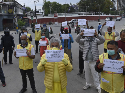
CoronaVirus may have stopped working in the entire world but it has not stopped the tension over the borders. The tension between Nepal, our neighboring Himalayan country, and India has started when Nepal’s government published new maps showing disputed areas of Lipulekh pass, Kalapani, and Limpiyadhura in its boundary.
They passed the constitutional amendment unanimously in the lower house of the Nepal parliament on Saturday, and another one expected to go through the upper house this week regarding the change in the map of Nepal.
The Indian government has passed the new maps last year depicting the Kalapani area as its territory, which leads to protests by Nepalese people. On which Nepal said, it has “consistently maintained” that as per the Sugauli Treaty of 1816, “all the territories east of Kali (Mahakali) river, including Limpiyadhura,Kalapani, and Lipulekh, belong to Nepal”. 
Sources say that Nepal tried to have talks regarding the boundary issue with the Indian government but they didn’t respond. “International borders are decided by mutual agreements irrespective of what we have published or the actual control of the territory by a state. It has to be concluded and settled through mutual treaties and understanding,” said a highly placed source in the Nepalese government.
On Friday, Nepal Army Police Force which guards the border killed an Indian civilian and injured the other two near the border across Sitamarhi district of Bihar. Indian officials tried to downplay the situation. “This is a completely local issue with no country-to-country or force-to-force ramifications. The issue arose on the spot and the local police from either side are engaged with each other to sort the matter out. Our DIG is also in touch with the DIG of Nepal APF and there is absolutely no tension on the border,” SSB DG Chandra had said.
Nepal also holds India responsible for the increased number of coronavirus cases in Nepal. It’s Prime Minister K.P.Sharma Oli claimed that 85% of coronavirus cases are those who have returned from India.
Another step which leads to staining in Nepal-India relations is the 80-km-long crucial road which connects Lipulekh pass with Dharchula in Uttarakhand, inaugurated by Defence Minister Rajnath Singh on May 8. This road according to the Indian government lies in its territory completely but the Napalese government claims that it passes through its territory.
If the tension between countries continues to grow, then it can lead to a number of bad consequences as we have already lost a life, and if this continues this way it can lead to more deaths on either side. It is the need of the hour to talk and find out the proper solution for the disputes.
[zombify_post]